In turn, these physical conditions play a fundamental role in determining a lake’s ecology and biogeochemistry. To understand how and why a lake behaves the way it does, it is important to observe those meteorological conditions. In addition, real-time, over-water meteorological conditions are a vital part of providing information about lake conditions to people working or recreating on the lake, from beachgoers to commercial and recreational boaters. To this end, the Large Lakes Observatory has deployed a pair of meteorological buoys in the western arm of Lake Superior in the ice-free months for over ten years.
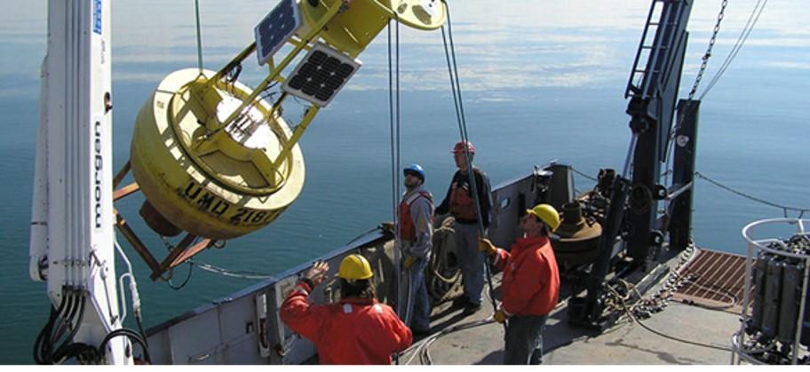
The buoys are deployed from the R/V Blue Heron in the spring- as early as we can convince the ship’s crew to get us out there- and retrieved in late fall, as they are not designed to withstand ice cover. These cruises are frequently the earliest and latest cruises, respectively, in the Blue Heron’s yearly schedule. Half-day cruises like these provide us with an opportunity to get people out on the boat that would not normally have the opportunity to sail on the Blue Heron; we have taken plenty of students out for their first experience on the water, as well as administrators, fellow faculty at UMD who don’t typically use the Blue Heron, local journalists, and even the janitor for RLB, who has always been curious about what we are up to on the lake.
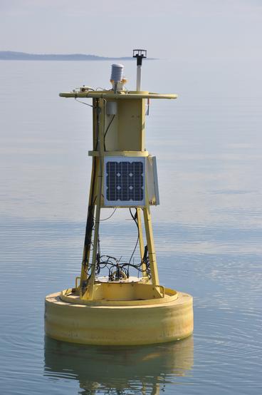
The buoys collect a wide range of meteorological and water quality parameters. Measured meteorological parameters include: wind speed and direction, air temperature and relative humidity, shortwave (sunlight) and longwave (infrared) radiation, barometric pressure, and precipitation; this set of observations was chosen specifically to allow researchers to estimate how heat and momentum are transferred between the lake and the overlying atmosphere. Surface wave data (significant wave height, wave direction, and period) is collected using accelerometers mounted on the buoy hulls, and water temperature is collected at several depths using a string of thermistors connected to the buoy. In recent years, we have begun to experiment with placing multi-parameter sensor packages on the buoys to measure water quality parameters such as turbidity (clarity), dissolved oxygen, chlorophyll fluorescence, and others, though these sensors are more difficult to maintain and subject to marine fouling. Finally, buoys are equipped with a Global Positioning Service (GPS) antenna, to provide us with notice if the buoy becomes detached from its anchor and becomes adrift (this has happened once; we managed to catch up with the buoy close to Two Harbors; a design flaw was identified and equipment was modified before being redeployed).
All of these sensors are integrated into a datalogger, which is programmed to periodically retrieve measurements from the sensors. It in turn is connected to a cell-phone modem, which allows data to be sent to a computer in the Physical Limnology Lab in RLB. From there, the data is processed, and disseminated to the National Data Buoy Center (NDBC, where they are known as 45027 and 45028) and the Great Lakes Observing System (GLOS). In addition, we host our own website (www.d.umn.edu/buoys) which, provides visualizations of the real-time data and hosts the raw data in a variety of formats. On a more whimsical note, several years ago, a former technician wrote a Twitter-bot which posts a tweet with current meteorological conditions every two hours- you can follow the buoys on Twitter at @UMDbuoys (nearly 900 other people do already).
The data is available on a variety of platforms and used by a wide variety of users; the commercial and recreational fishing communities are appreciative of the real-time nature of the data, and allow people to quickly assess if conditions are conducive to a nice day on the water or not. Perhaps our most dedicated user is the National Weather Service’s Duluth office. They use the data to inform them on small craft and beach warnings, to help during periods of lakeshore flooding, and to tune and verify their forecast models. In a recent letter of support, the NWS stated “Without the near and offshore buoys that are deployed by UMD LLO, we would be flying blind for any marine concerns in the western arm of Lake Superior”. On a recent fall recovery cruise, we were fortunate to have one of the staffers from NWS-Duluth on board with us to observe our operations and generally to foster good relations with their office. When one of the buoys was recovered and safely on deck, the staffer texted to her colleagues “We just recovered the nearshore buoy”. One of her colleagues immediately replied: “Put it back!”.